Werrong Beach Track Nude Walkers
This group is for people who like a safe naturist bush walk. Werrong Beach is 30 minutes South of Sydney. The track is 40 minutes each way and exclusively serves the access for Werrong Beach. Werrong Beach is a lgal nudist beach so nudity along the trail should not cause offence. To make it easy to organise I propose a 7.00am walk every Sunday during the winter season and 6.00am in daylight...
Werrong track is closed
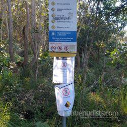
Return to DiscussionsWerrong beach still unaccessible. The track is closed...i went to check it out...first 2/3 ok then trees across tracks and plenty of water on track...the way down to the beach has been washed away , now replaced by a 20+ meters drop. Last 150 / 200 meters of the hill is UNSTABLE! and detaching from the rest of the hill! The detachment crack is obvious. IT S A REAL HAZARD! someone has installed a rope to go down but it is on the unstable zone. I do not recommend stepping in that zone, it could go at anytime.
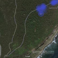
I just added a google map...areas in blue are the flooded track with heaps of water gushing around, the one circled is the clearing that is now a pond, the red area is totally gone, and yellow area is the unstable zone marked by large cracks in the ground..the area is detaching from the rest of the hill. but the area above may be well unstable as well as it seems saturated with water. The markings are approximation only.
When i realised i was standing on an unstable hill i bolted out , taking photos was the last thing in my mind at that time. Having said so i took few photos and short videos on the way down and up in the "safe area".
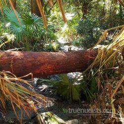
I have attached a photo...a tree across the track. From that point the track is soaked with water everywhere. I ll say this is what i' ll classify as the limit between safe and unsafe zone. But i m not an expert so if they have closed the track they must know the danger.
I don t think they will reopen it anytime soon. Being a protected area they just can force the unstable zone to collapse , fortify the hill and set a new track...so if they wait for nature to do it all, it is going to take years.
An alternative would be to create a safe track about 300m from the unsafe zone, crossing the little creek , then all the way to the beach...i believe that is the only way we will be able to enjoy that beach again...but i also believe people will make that new track before the council even think about it.
That's a shame. I guess I won't be going back anytime soon, but then I haven't been in quite a while.I have attached a photo...a tree across the track.
That looks like the Palm Jungle. Not the first time they have had trees fall across the track, and it won't be the last.An alternative would be to create a safe track about 300m from the unsafe zone, crossing the little creek , then all the way to the beach...i believe that is the only way we will be able to enjoy that beach again...but i also believe people will make that new track before the council even think about it.
It's not the council but the NPWS that are responsible for Werrong and the track. Council just get legal control over its clothing-optional status thanks to some stupid state legislation. Councils should have no control over NPWS land.
Yes there were, there is and there will be tree falling across the track. I just used that photo as a marker of where the track is then flooded.
It doesn t matter who is responsible for the track, they are not going to fix anything till the detaching part of the hill has not fallen down and the area is stable. The detaching part is massive and the cracks large and obvious. Anyone on the beach below could easily be reached by the landslide of this size


